-
You are here:
- Homepage »
- United States »
- Oregon » Pacific City

Pacific City Destination Guide
Explore Pacific City in United States
Pacific City in the region of Oregon with its 1,035 inhabitants is a town in United States - some 2,412 mi or ( 3881 km ) West of Washington , the country's capital city .
Current time in Pacific City is now 10:56 PM (Friday) . The local timezone is named " America/Los Angeles " with a UTC offset of -7 hours. Depending on the availability of means of transportation, these more prominent locations might be interesting for you: Albany, Beaver, Corvallis, Eugene, and Happy Hollow. Since you are here already, make sure to check out Albany . We encountered some video on the web . Scroll down to see the most favourite one or select the video collection in the navigation. Where to go and what to see in Pacific City ? We have collected some references on our attractions page.
Videos
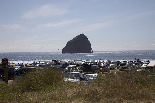
Car stuck on beach
Car gets stuck in sand on Haystack rock beach ..
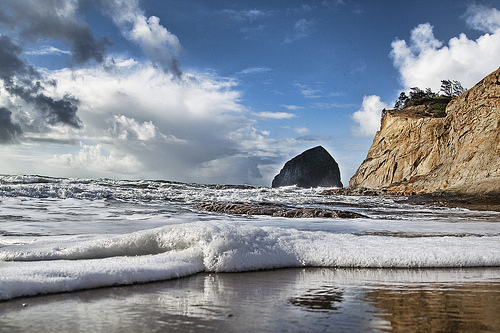
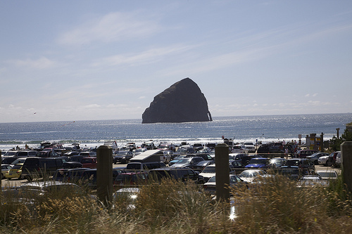
Cape Kiwanda
Cape Kiwanda in Pacific City Oregon, on the Oregon Coast. Cape Kiwanda is part of the three capes scenic drive on the Oregon Coast. Climb to the top of Cape Kiwanda, and enjoy all its beauty! Drive th ..
Cape Kiwanda at the Oregon Coast
Cape Kiwanda at the Oregon Coast on a beautiful winter day. ..
Car Stuck on Beach
Car pulled out by truck on Beach in Pacific City Oregon ..
Videos provided by Youtube are under the copyright of their owners.
Interesting facts about this location
Pacific City, Oregon
Pacific City is a census-designated place (CDP) and unincorporated community in Tillamook County, Oregon, United States. The population was 1,027 at the 2000 census. Pacific City's main attraction is the Cape Kiwanda State Natural Area.
Located at 45.21 -123.96 (Lat./Long.); Less than 0 km away
Nestucca Bay
Nestucca Bay is a bay formed by the confluence of the Nestucca River and the Pacific Ocean located in northwest Oregon in the United States. It is located near the town of Pacific City in southwestern Tillamook County, approximately 12 mi (19 km) south of Cape Lookout. The bay is a bar-built estuary and totals 1,000 acres in area. The Nestucca and Little Nestucca rivers enter the bay. The bay is separated from the Pacific Ocean by the Nestucca Spit which includes Bob Straub State Park.
Located at 45.17 -123.97 (Lat./Long.); Less than 4 km away
Oretown, Oregon
Oretown is an unincorporated community in Tillamook County, Oregon, United States. It is located on U.S. Route 101 about four miles north of Neskowin. In 1877, settlers James B. Upton and S. H. Rock petitioned Senator John H. Mitchell asking for a mail route to Grand Ronde and a post office. Upton owned a seal marked "Oregon City", so he suggested the new post office be named "Ore City" and he would alter the seal so it could be used for the new community.
Located at 45.15 -123.96 (Lat./Long.); Less than 5 km away
Nestucca High School
Nestucca High School is a public high school in Cloverdale, Oregon, United States.
Located at 45.20 -123.89 (Lat./Long.); Less than 6 km away
Little Nestucca River
The Little Nestucca River is a river, approximately 20 mi (32 km) long, on the Pacific coast of northwest Oregon in the United States. It drains an area of the Central Oregon Coast Range west of the Willamette Valley. It rises in the Van Duzer State Forest in northwestern Polk County, in the mountains west of Salem. It flows generally northwest, through Siuslaw National Forest and enters Nestucca Bay on the Pacific near Pacific City. The Little Nestucca River crosses under the U.S.
Located at 45.14 -123.90 (Lat./Long.); Less than 9 km away
Pictures
Related Locations
Information of geographic nature is based on public data provided by geonames.org, CIA world facts book, Unesco, DBpedia and wikipedia. Weather is based on NOAA GFS.