Discover Whitehorse in Canada
Whitehorse in the region of Yukon with its 23,272 habitants is a town located in Canada - some 2,572 mi or ( 4140 km ) North-West of Ottawa , the country's capital .
Local time in Whitehorse is now 09:31 AM (Thursday) . The local timezone is named " America/Whitehorse " with a UTC offset of -7 hours. Depending on your flexibility, these larger cities might be interesting for you: Juneau City and Borough, and Sitka. When in this area, you might want to check out Juneau City and Borough . We found some clip posted online . Scroll down to see the most favourite one or select the video collection in the navigation. Are you looking for some initial hints on what might be interesting in Whitehorse ? We have collected some references on our attractions page.
Videos
2011 Yukon und Alaska mit dem Wohnmobil - Teil 1
Kanada 2011 - Yukon und Alaska - Eine Wohnmobilreise durch subarktische Regionen Kanadas und der USA. Teil 1. 5500 km führen von Whitehorse über Atlin, den Alaska Highway, Watson Lake, Robert Campbell ..
Air North HS-748 - Engine Start-up and Take-off Rwy Rwy 31L from Whitehorse Int'l (YXY), Canada
Window view from Air North's 4N207J service from Whitehorse (YXY) to Inuvik (YEV) via Dawson City (YDA). The airframe pictured is C-FCSE, a 1970-built HS-748-2A series aircraft showing off some great ..
Whitehorse Transit Nova Bus LFS
Here we are on Route #2 Airport-Hillcrest-Lobird. Our ride starts at Lobird Road as our bus makes a left turn on to the Alaska Highway. We then travel along Robert Service Way, following the Yukon Riv ..
The Alaska Highway - The Yukon and northern BC Sarzmc's photos around Whitehorse, Canada
Preview of Sarzmc's blog at TravelPod. Read the full blog here: www.travelpod.com This blog preview was made by TravelPod using the TripAdvisor™ TripWow slideshow creator. Learn more about these video ..
Videos provided by Youtube are under the copyright of their owners.
Interesting facts about this location
Qwanlin Plaza
Qwanlin Plaza (also known as "Qwanlin Mall") is a shopping mall in Whitehorse, Yukon Territories, Canada located on the north end of downtown Whitehorse.
Located at 60.72 -135.05 (Lat./Long.); Less than 0 km away
Diocese of Yukon
The Anglican Diocese of Yukon is a diocese of the Ecclesiastical Province of British Columbia and Yukon of the Anglican Church of Canada. It comprises 15 congregations serving 24 communities in the Yukon and parts of northern British Columbia. The Diocese was formed in 1890 when the Diocese of Mackenzie River was divided. Originally the Diocese of Selkirk, the name of the diocese was changed to Yukon in 1907. The diocesan bishop since 1995 has been the Rt. Rev.
Located at 60.72 -135.05 (Lat./Long.); Less than 0 km away
Yukon Legislative Building
The Yukon Legislative Building is home to the Yukon Legislative Assembly. Located in Whitehorse, Yukon, the building is a three-storey white steel-clad structure. Before relocating to Whitehorse, the legislature met at the Yukon Territorial Government Administration Building in Dawson City from 1907 to 1953 (and now home to Yukon College).
Located at 60.72 -135.05 (Lat./Long.); Less than 0 km away
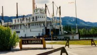
SS Klondike
The SS Klondike was the name of two sternwheelers, the second now a national historic site located in Whitehorse, Yukon, Canada. Both ran freight between Whitehorse and Dawson City along the Yukon River from 1921-1936 and 1936-1950, respectively. The Klondike I was built in 1921 and had the distinction of having 50% more capacity than a regular sternwheeler, while still having the shallow draft and meeting the size requirements in order to travel down the Yukon River.
Located at 60.71 -135.05 (Lat./Long.); Less than 0 km away
Whitehorse trolley
The Whitehorse trolley is a heritage streetcar service in Whitehorse, Yukon, Canada. It uses a single reconditioned trolley which carries tourists along Whitehorse's waterfront along the Yukon River. It runs from the Rotary Peace Park, located on the south end of the city centre, up to the north end of the city centre at Spook Creek Station. The car originally served the trolley/streetcar system of Lisbon, Portugal, from 1925 to 1978.
Located at 60.72 -135.05 (Lat./Long.); Less than 1 km away
Pictures
Related Locations
Information of geographic nature is based on public data provided by geonames.org, CIA world facts book, Unesco, DBpedia and wikipedia. Weather is based on NOAA GFS.


