-
You are here:
- Homepage »
- France »
- Languedoc-Roussillon » Saint-Bonnet-du-Gard

Saint-Bonnet-du-Gard Destination Guide
Discover Saint-Bonnet-du-Gard in France
Saint-Bonnet-du-Gard in the region of Languedoc-Roussillon with its 631 habitants is a town located in France - some 356 mi or ( 573 km ) South of Paris , the country's capital .
Local time in Saint-Bonnet-du-Gard is now 05:33 AM (Saturday) . The local timezone is named " Europe/Paris " with a UTC offset of 1 hours. Depending on your flexibility, these larger cities might be interesting for you: Vers-Pont-du-Gard, Vallabregues, Uzès, Tavel, and Tarascon. When in this area, you might want to check out Vers-Pont-du-Gard . We found some clip posted online . Scroll down to see the most favourite one or select the video collection in the navigation. Are you looking for some initial hints on what might be interesting in Saint-Bonnet-du-Gard ? We have collected some references on our attractions page.
Videos
Pont du Gard 2 Novembre 2008
Le Gardon en crue ..
La garrigue et le Pont du Gard (Gard - France)
(F) Près de vingt siècles nous séparent de la construction d'un des ouvrages de génie civil les plus connus à travers le monde. Symbole de la puissance de la civilisation romaine, il a traversé le tem ..
Crazy American tourists jump off the Pont du Gard!
Well, not actually the Pont du Gard, but the cliff right next to it :) ..
Pont du Gard - GroupeF - June 25 - 2010
France - Pont du Gard GroupeF light, music and pyrotechnic show Conception: Christophe Bertonneau - Creation - GroupeF www.groupef.com ..
Videos provided by Youtube are under the copyright of their owners.
Interesting facts about this location
Pont du Gard
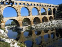
The Pont du Gard (English: Bridge of the Gard) is an ancient Roman aqueduct bridge that crosses the Gardon River in Vers-Pont-du-Gard near Remoulins, in the Gard département of southern France. It is part of the Nîmes aqueduct, a 50 km-long structure built by the Romans to carry water from a spring at Uzès to the Roman colony of Nemausus.
Located at 43.95 4.54 (Lat./Long.); Less than 2 km away
Circuit de Lédenon
Circuit de Lédenon is a motor racing circuit located in southern France, next to the town of Lédenon.
Located at 43.92 4.51 (Lat./Long.); Less than 3 km away
Pont de Bornègre
The Pont de Bornègre (or Pont de Bordnègre) is an ancient bridge of the Roman aqueduct to Nîmes, which also includes the famous Pont du Gard, between the communes of Saint-Maximin, and Argilliers. It is located at the upper reaches of the approximately 50 km long aqueduct, 6,745 m downstream of the Eure source and 9,061 m upstream of the Pont du Gard.
Located at 43.98 4.48 (Lat./Long.); Less than 8 km away
Gardon
The Gardon or Gard is a river in southern France. It is the namesake of the Gard département. Several of its tributaries are also called Gardon. The Gardon is 133 km long including its longest tributary "Gardon de Saint-Jean". It rises in the Cévennes range of mountains and ends into the Rhône River (right-side tributary) at Comps, north of Beaucaire, across from Vallabrègues.
Located at 43.85 4.61 (Lat./Long.); Less than 10 km away
Abbey of Saint-Roman
The Abbey of Saint-Roman (Abbaye de Saint-Roman), is a cave monastery located in the communes of Beaucaire and Comps, in the Gard département of France. The site, which includes the ruins of a castle, the château de Saint-Roman-d'Aiguille, has been protected by the French Ministry of Culture as a monument historique since 1990 and includes a chapel, cloisters, terrace, tombs and walls. It was constructed in the 9th, 10th, 12th and 15th centuries.
Located at 43.84 4.61 (Lat./Long.); Less than 11 km away
Pictures
Historical Weather
Related Locations
 Saint-Bonnet-de-Vieille-Vigne (Bourgogne)
 Saint-Bonnet-de-Valclerieux (Rhône-Alpes)
 Saint-Bonnet-des-Quarts (Rhône-Alpes)
 Saint-Bonnet-des-Bruyeres (Rhône-Alpes)
 Saint-Bonnet-de-Salers (Auvergne)
 Saint-Bonnet-de-Rochefort (Auvergne)
 Saint-Bonnet-de-Mure (Rhône-Alpes)
 Saint-Bonnet-de-Montauroux (Languedoc-Roussillon)
Information of geographic nature is based on public data provided by geonames.org, CIA world facts book, Unesco, DBpedia and wikipedia. Weather is based on NOAA GFS.

