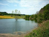
Discover Aura im Sinngrund in Germany
Aura im Sinngrund in the region of Bavaria with its 1,063 habitants is a place located in Germany - some 232 mi or ( 373 km ) South-West of Berlin , the country's capital .
Local time in Aura im Sinngrund is now 10:43 PM (Friday) . The local timezone is named " Europe/Berlin " with a UTC offset of 1 hours. Depending on your mobility, these larger cities might be interesting for you: Zeitlofs, Wurzburg, Steinau an der Strasse, Rieneck, and Partenstein. When in this area, you might want to check out Zeitlofs . We discovered some clip posted online . Scroll down to see the most favourite one or select the video collection in the navigation. Are you looking for some initial hints on what might be interesting in Aura im Sinngrund ? We have collected some references on our attractions page.
Videos
Sinntal-Jossa, Erholungsort im Naturpark Spessart
Bilderfolge vom Dorf und der Landschaft www.jossa-spessart.de ..
Perlen der Jossa, Europäischer Kulturradweg im Jossatal
Ein ca. 28 km langer Radweg zwischen Villbach und Jossa mit Infotafeln über die Dörfer des Jossatales und deren Geschichte. Jährlich eine gemeinschaftliche Radlertour mit einem schönen Rahmenprogramm ..
Ricardo Villalobos @ Love Family Park 04-07-2010 Lemon 8 Model 8
yo, Fabian, Donna Eliana, Simona, Gianluca. ..
100 Jahre Landgasthof Joßgrund, Sinntal-Jossa
Der Landgasthof Joßgrund feiert sein 100-jähriges Bestehen ..
Videos provided by Youtube are under the copyright of their owners.
Interesting facts about this location
Jossa
Jossa is a village in the German municipality of Sinntal in Main-Kinzig-Kreis in the state of Hesse. Jossa lies within the Spessart nature park and is a state-recognised health resort. The village has 664 inhabitants and covers an area of 181 hectares . Its councillor is Günter Walther (2008).
Located at 50.24 9.59 (Lat./Long.); Less than 6 km away
Aura (Sinn)
The Aura is an 8 kilometres tributary of the Sinn River in Bavaria, Germany.
Located at 50.15 9.65 (Lat./Long.); Less than 7 km away
Hermannskoppe
Hermannskoppe is a mountain of Hesse, Germany.
Located at 50.11 9.52 (Lat./Long.); Less than 9 km away
Schmale Sinn
Schmale Sinn is a river of Hesse, Germany.
Located at 50.25 9.65 (Lat./Long.); Less than 9 km away
Rieneck Castle
Rieneck Castle is a castle built by Ludwig I, Count of Loon and Rieneck, in the year 1151. The city of Rieneck is situated about 80 km east of Frankfurt. The castle now serves as a Scouting facility and is owned by the German Christian Guide and Scout Association, VCP. The castle's programme includes many interesting Scouting activities such as arts and crafts, pioneering and middelage trades and offers accommodation, Internet connection (see image to the right) and a campsite.
Located at 50.09 9.65 (Lat./Long.); Less than 11 km away
Pictures
Historical Weather
Related Locations
Information of geographic nature is based on public data provided by geonames.org, CIA world facts book, Unesco, DBpedia and wikipedia. Weather is based on NOAA GFS.


