-
You are here:
- Homepage »
- Greece »
- Peloponnese » Kato Almyri

Kato Almyri Destination Guide
Discover Kato Almyri in Greece
Kato Almyri in the region of Peloponnese is a town located in Greece - some 40 mi or ( 64 km ) West of Athens , the country's capital .
Local time in Kato Almyri is now 03:30 PM (Friday) . The local timezone is named " Europe/Athens " with a UTC offset of 2 hours. Depending on your flexibility, these larger cities might be interesting for you: Xilokeriza, Lacedaemon, Patras, Nafplion, and Loutraki. When in this area, you might want to check out Xilokeriza . We found some clip posted online . Scroll down to see the most favourite one or select the video collection in the navigation. Are you looking for some initial hints on what might be interesting in Kato Almyri ? We have collected some references on our attractions page.
Videos
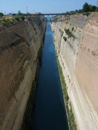
Contiki 07 - The Corinth Channel
Ok, one of my coolest clips from the whole trip, we were just in the right place at the right time - was pretty happy about this one... ..
Greece: Corinth Canal transit, #2
On the afternoon of 24 May 2007 I was a passenger on the 10000-ton Seabourn Spirit when that vessel made a transit of the 3.9-mile (6.3-km)-long Corinth Canal from west to east. The 68.9-foot-wide (21 ..
Greece Corinth Channel
Greece Corinth Channel 2007 Греция Коринфский канал members.virtualtourist.com ..
Ισθμός Κορίνθου-Corinth Isthmus (greece)
Ship passes narrow canal ..
Videos provided by Youtube are under the copyright of their owners.
Interesting facts about this location
Loutra Elenis
Loutra Elenis is a village in Corinthia, Greece. It is situated on the coast of the Saronic Gulf, about 10 km southeast of Corinth. It is part of the community of Galataki within the municipal unit of Saronikos. It is situated on the Greek National Road 70 between Corinth and Epidaurus.
Located at 37.87 23.00 (Lat./Long.); Less than 2 km away
Kechries
Kechries is a village in the municipality of Corinth in Corinthia in Greece. It is part of the community of Xylokeriza. It is located about 7 kilometres southeast of Corinth and 7 kilometres southeast of the Epidavros interchange with GR-8A/E94, north of Galataki and Kato Almyri, east of Examilia, southeast of Xylokeriza, south of Kiras Vrysi and west/southwest of modern Isthmia.
Located at 37.88 22.99 (Lat./Long.); Less than 4 km away
Oneia Mountains
The Oneia Mountains (Greek: Όνεια Όρη or Oneia Ori) are a low mountain range in Corinthia, northeastern Peloponnese, Greece. The range extends 9km from west to east, starting west of the village of Solomos, passing south of the village of Xylokeriza and ending near the Bay of Kechries, on the Saronic Gulf. The highest peaks are Profitis Ilias, at 581m, and Oxy, at 562 meters. The other two peaks measure 507m and 229m respectively.
Located at 37.87 22.93 (Lat./Long.); Less than 7 km away
Athikia
Athikia (Αθίκια) is the seat of the former municipality of Saronikos, located in the regional unit of Corinthia in Greece. Athikia has a population of approximately 2000 and is located 15 km South of the city of Corinth.
Located at 37.82 22.93 (Lat./Long.); Less than 7 km away
Temple of Isthmia
The Temple of Isthmia is an ancient Greek temple on the Isthmus of Corinth dedicated to the god Poseidon and built in the Archaic Period. It is about 16 kilometers east of ancient Corinth. It appears to have been constructed in the seventh century BC though was later destroyed in 470 BC and rebuilt as the Temple of Poseidon at Isthmia in c. 440 BC during the Classical period.
Located at 37.92 22.99 (Lat./Long.); Less than 7 km away
Pictures
Historical Weather
Related Locations
Information of geographic nature is based on public data provided by geonames.org, CIA world facts book, Unesco, DBpedia and wikipedia. Weather is based on NOAA GFS.

