Discover Platanos in Greece
Platanos in the region of Thessaly with its 811 habitants is a town located in Greece - some 156 mi or ( 252 km ) North-West of Athens , the country's capital .
Local time in Platanos is now 07:37 AM (Tuesday) . The local timezone is named " Europe/Athens " with a UTC offset of 2 hours. Depending on your flexibility, these larger cities might be interesting for you: Trikala, Raxa, Pigi, Pyrgetos, and Megalochorion. When in this area, you might want to check out Trikala . We found some clip posted online . Scroll down to see the most favourite one or select the video collection in the navigation. Are you looking for some initial hints on what might be interesting in Platanos ? We have collected some references on our attractions page.
Videos
trikala mtx audio 6 15's 7500 subwoofers in a honda civic
car audio xtreme blowing the city ..
Meteora Greece
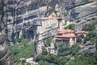
Other photo on light-n-dark.com Small tour in Meteora - cloisters on cliff, one of the Greeks miracle. The spring 2008. The Metéora (Greek Μετέωρα, "suspended in the air") is one of the largest and mo ..
Τρίκαλα φανταστικός Μύλος Ξωτικών ξενάγηση ΜΜΕ 8-12-2011
Ξενάγηση των ΜΜΕ στο φανταστικό κόσμο του Μύλου των Ξωτικών στα Τρίκαλα (βίντεο -- φωτό) Αναμφισβήτητα ο Μύλος των Ξωτικών στο πάρκο Ματσόπουλου στα Τρίκαλα, αποτελεί αυτή τη στιγμή πόλο έλξης για μικ ..
TRIKALA MTX 9500 XTREME SUB EXCURCION
car audio xtreme blowing the city ..
Videos provided by Youtube are under the copyright of their owners.
Interesting facts about this location
Rizoma
Rizoma is a village in the Trikala regional unit, Thessaly, Greece. In the 2001 census it reported 1380 residents. It lies at 160 meters above sea level, 12 km north of the city of Trikala. It has an agricultural economy with tobacco being the main product. The village is the seat of the Paralithaioi municipal unit and it is inhabited by Karagounides, the most commonly used name for the residents of the Thessalian plain.
Located at 39.67 21.73 (Lat./Long.); Less than 3 km away
Trikala Municipal Stadium
The Trikala Municipal Stadium (Greek: Δημοτικό Στάδιο Τρικάλων, Dimotiko Stadio Trikalon) is a sports stadium in Trikala, Greece. It is used for football matches of the local team Trikala F.C. and athletics events. The stadium frequently serves as a neutral venue for penalised teams and has hosted games between major Greek Clubs in the past. It has also served as the venue for the Athens Grand Prix Tsiklitiria as well as hosted concerts.
Located at 39.55 21.78 (Lat./Long.); Less than 12 km away
Monastery of the Holy Trinity, Meteora
The Holy Trinity Monastery (Greek: Μονή Αγίας Τριάδος) (also known as Agia Triada, Ayías Triádhos, Ayia Triada; all meaning "Holy Trinity") is an Eastern Orthodox monastery in central Greece, situated in the Peneas Valley northeast of the town of Kalambaka.
Located at 39.71 21.64 (Lat./Long.); Less than 13 km away
Meteora
The Metéora (Greek: Μετέωρα, lit. "middle of the sky", "suspended in the air" or "in the heavens above" — etymologically related to "Meteorite") is one of the largest and most important complexes of Eastern Orthodox monasteries in Greece, second only to Mount Athos. The six monasteries are built on natural sandstone rock pillars, at the northwestern edge of the Plain of Thessaly near the Pineios river and Pindus Mountains, in central Greece. The nearest town is Kalambaka.
Located at 39.71 21.63 (Lat./Long.); Less than 13 km away
Pelinna
Pelinna was an ancient Greek city with a celebrated temple of Zeus Pelinnaeus, in Estiaeotis, ancient Thessaly. Pelinna was situated between Tricca and Pharcadon, near modern Palaiogardiki. The city gained particular prominence in the fourth century BC through its alliance with Philip II of Macedon. Among other archaeological evidence of the religious significance of Pelinna are two Orphic gold tablets found in 1985 on the site of Petroporos, dating to the late 4th century BC.
Located at 39.58 21.93 (Lat./Long.); Less than 16 km away
Pictures
Historical Weather
Related Locations
Information of geographic nature is based on public data provided by geonames.org, CIA world facts book, Unesco, DBpedia and wikipedia. Weather is based on NOAA GFS.


