-
You are here:
- Homepage »
- India »
- India (general) » Gyalshing

Gyalshing Destination Guide
Explore Gyalshing in India
Gyalshing in the region of India (general) with its 869 inhabitants is a place in India - some 680 mi or ( 1094 km ) East of New Delhi , the country's capital city .
Time in Gyalshing is now 04:42 PM (Monday) . The local timezone is named " Asia/Kolkata " with a UTC offset of 5.5 hours. Depending on your budget, these more prominent locations might be interesting for you: Dhaka, Paro, Tsimasham, Soreng, and Sombari. Since you are here already, consider visiting Dhaka . We saw some hobby film on the internet . Scroll down to see the most favourite one or select the video collection in the navigation. Where to go and what to see in Gyalshing ? We have collected some references on our attractions page.
Videos
India Sikkim Rinchenpong Yangsum Heritage Farm India Hotels India Travel Ecotourism Travel To Care
Visit us at www.traveltocare.com A presentation of Travel To Care for Hotel Yangsum Heritage Farm Rinchenpong in Sikkim India Hotels India Travel Ecotourism. ..
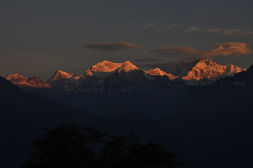
Kanchenjunga water falls
This beautiful waterfall is very close to Pelling, Sikkim. Its generally included in all sight seeing tours in & around Pelling ..
Kanchenjunga from Kaluk
..
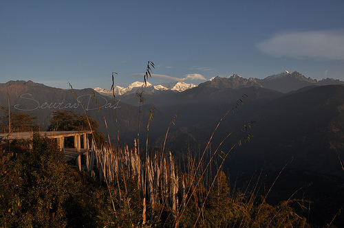
View of Pelling - a Himalayan Mountain Town - Sikkim, India
View of Pelling - a Himalayan Mountain Town - Sikkim, India, as seen from the Helipad in Pelling. ..
Videos provided by Youtube are under the copyright of their owners.
Interesting facts about this location
Gyalshing
Gyalshing or Geyzing is the capital of the district of West Sikkim in the Indian state of Sikkim. The town is connected to the capital Gangtok by a metalled road. Geyzing is also connected to the West Bengal towns of Darjeeling and Kalimpong via Jorethang. A few kilometres north is the town of Pelling. The town has a large Nepali population, and the Nepali language is the predominant language of the region. The town is situated at an altitude of about 6,500 feet (1,900 m).
Located at 27.28 88.27 (Lat./Long.); Less than 0 km away
Pelling
Pelling is a town in the district of West Sikkim, India. Pelling is nestled at an altitude of 2,150 m (7,200 feet). The town is located at a distance of 10 km from the district headquarters of Geyzing. A regular bus service connects the two towns. However with the influx of tourists, the region is undergoing a metamorphosis, with the roads being repaired and hotels being set up. The mighty Himalayas and the Kanchenjanga may be viewed at close quarters from Pelling.
Located at 27.30 88.23 (Lat./Long.); Less than 4 km away
Buddha Park of Ravangla
The Buddha Park of Ravangla, also known as Tathagata Tsal, is situated near Rabong in South Sikkim district, Sikkim, India. It was constructed in 2006-13 and features a 130-foot high statue of Lord Buddha as its centerpiece. The site was chosen within the larger religious complex of the Rabong Gompa (Monastery), itself a centuries-old place of pilgrimage. Also nearby is Ralang Monastery, a key monastery in Tibetan Buddhism.
Located at 27.31 88.36 (Lat./Long.); Less than 10 km away
Majitar
Majitar is a small Village in East Sikkim in the Indian state of Sikkim. The nearest Town are Rangpo (4 K. M) and Singtam (7 K. M). It is about 200 m above sea level giving it a sub-tropical climate. Majitar has a large population of Nepalese, Bhutia, Marwari and Bengali. Although students from all over the country, mainly Bihar, Uttar Pradesh, Jharkhand and Guwahati lives there at Sikkim Manipal Institute of Technology.
Located at 27.18 88.27 (Lat./Long.); Less than 11 km away
Khecheopalri Lake
Khecheopalri Lake, originally known as Kha-Chot-Palri (meaning the heaven of Padmasambhava), is a sacred Lake for both Buddhists and Hindus, which is believed to be a wish fulfilling lake. It is located near Khecheopalri village, 147 kilometres west of Gangtok and 34 kilometres to the northwest of Pelling town in the West Sikkim district of the Northeastern Indian state of Sikkim. The local name for the lake is Sho Dzo Sho, which means "Oh Lady, Sit Here".
Located at 27.37 88.21 (Lat./Long.); Less than 12 km away
Pictures
Historical Weather
Related Locations
Information of geographic nature is based on public data provided by geonames.org, CIA world facts book, Unesco, DBpedia and wikipedia. Weather is based on NOAA GFS.