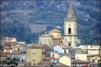
Delve into Novara di Sicilia in Italy
Novara di Sicilia in the region of Sicily with its 1,731 residents is a city in Italy - some 302 mi or ( 487 km ) South-East of Rome , the country's capital .
Current time in Novara di Sicilia is now 11:00 AM (Monday) . The local timezone is named " Europe/Rome " with a UTC offset of 1 hours. Depending on your travel modalities, these larger destinations might be interesting for you: Taormina, Syracuse, Santa Lucia del Mela, San Marco, and San Basilio. While being here, make sure to check out Taormina . We encountered some video on the web . Scroll down to see the most favourite one or select the video collection in the navigation. Are you curious about the possible sightseeing spots and facts in Novara di Sicilia ? We have collected some references on our attractions page.
Videos
sicily novara di sicilia
bike trip april 2009 in sicily. road S185 direction Novara di Sicilia. ..
PIRAINO - LA TORRE SARACENA
PIRAINO EI FUOCHI D'ARTIFICIO... ..
Lipari
Lipari est la plus grande des Îles Éoliennes dans la Mer Tyrrhénienne .Province de Messine (Italie) ..
Litanie SS Angeli custodi 2012
Fondachelli Fantina 8 Luglio 2012 - Tradizionale cantata delle Litanie nel Quartiere Chiesa Vecchia. ..
Videos provided by Youtube are under the copyright of their owners.
Interesting facts about this location
Tindari
Tindari, anciently Tyndaris or Tyndarion is a small city in the comune of Patti, in the Province of Messina in Sicily, between Barcellona Pozzo di Gotto and Cefalù. Tindari has a famous sanctuary and is also famous for the poem "Vento a Tindari", written by Salvatore Quasimodo.
Located at 38.15 15.04 (Lat./Long.); Less than 17 km away
Battle of Tyndaris
The Battle of Tyndaris was a naval battle of the First Punic War, which took place off Tyndaris in 257 BC. Tyndaris was a Sicilian town founded as a Greek colony in 396 BC located on the high ground overlooking the Tyrrhenian Sea in the Gulf of Patti. Hiero II, the tyrant of Syracuse, allowed Tyndaris to become a base for the Carthaginians. The battle, took place in the waters between Tyndaris and the Aeolian Islands, with Gaius Atilius Regulus in command of the Roman fleet.
Located at 38.15 15.04 (Lat./Long.); Less than 17 km away
Peloritani
The Peloritani are a mountain range of north-eastern Sicily, in southern Italy, extending for some 65 km from Capo Peloro to the Nebrodi Mountains. At North and West they are bordered by the Tyrrhenian and Ionian Seas, respectively. The highest peaks are the Montagna Grande (1,374 m) and the Rocca Novara (1,340 m). The range is made up by a long series of peaks, with an average height of 800-1,000 m, intermingled with ridges and ravines.
Located at 38.05 15.33 (Lat./Long.); Less than 18 km away
Isola Bella (Sicily)
Isola Bella is a small island near Taormina, Sicily, southern Italy. Also known as The Pearl of the Ionian Sea, it is located within a small bay on the Ionian Sea; it was a private property until 1990, when it was bought by the Region of Sicily, being turned into a nature reserve, administrated by the Italian branch of the World Wide Fund for Nature. There is a narrow path that often connects the island to the mainland beach.
Located at 37.85 15.30 (Lat./Long.); Less than 24 km away
Barcelona Landing Ground
Barcelona Landing Ground is an abandoned World War II military airfield in Sicily, located in the southwestern suburbs of Milazzo. It was a temporary field built by the Army Corps of Engineers used as part of the Invasion of Italy in August 1943. The airfield primarily used by the United States Army Air Force Twelfth Air Force 86th Bombardment Group from 27 August until 22 September.
Located at 38.22 15.23 (Lat./Long.); Less than 24 km away
Pictures
Historical Weather
Related Locations
Information of geographic nature is based on public data provided by geonames.org, CIA world facts book, Unesco, DBpedia and wikipedia. Weather is based on NOAA GFS.


