-
You are here:
- Homepage »
- Netherlands »
- North Holland » Muiden

Muiden Destination Guide
Touring Muiden in Netherlands
Muiden in the region of North Holland is a city located in Netherlands - some 8 mi or ( 13 km ) East of Amsterdam , the country's capital city .
Time in Muiden is now 06:12 PM (Saturday) . The local timezone is named " Europe/Amsterdam " with a UTC offset of 1 hours. Depending on your travel resources, these more prominent places might be interesting for you: Weesp, Utrecht, Uitermeer, The Hague, and Naarden. Being here already, consider visiting Weesp . We collected some hobby film on the internet . Scroll down to see the most favourite one or select the video collection in the navigation. Check out our recommendations for Muiden ? We have collected some references on our attractions page.
Videos
Day trip in Holland - working windmill
Close shot of a working Dutch windmill a few miles east of Amsterdam. Used for pumping water out of the lake Naardermeer. For a clip of the interior of this windmill : www.youtube.com For routes and c ..
A. Piazzolla, arr. T. Fletcher - Jacinto Chiclana
Uitgevoerd door het A-orkest tijdens het jaarconcert van Weesper Accordeon Vereniging Paolo Soprani in de City of Wesopa op zaterdag 18 maart 2006. Het concert stond onder leiding van Tim Fletcher, de ..
Working corn windmill in Holland
Traditional working corn-mill in Holland, still in full use for grinding wheat. Windmill De Vriendschap (Friendship) is located in the small town of Weesp, east of Amsterdam. Exterior and interior sho ..
Weesp kwart Triatlon 2006
Open water Swimming competition part of the triatlon. true the nice little city "Weesp" near Amsterdam, The Netherlands. ..
Videos provided by Youtube are under the copyright of their owners.
Interesting facts about this location
Muiderslot
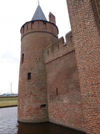
The Muiderslot is a castle in the Netherlands, located at the mouth of the river Vecht, some 15 kilometers southeast of Amsterdam, in Muiden, where it flows into what used to be the Zuiderzee. It's one of the better known castles in the Netherlands and has been featured in many television shows set in the Middle Ages.
Located at 52.33 5.07 (Lat./Long.); Less than 0 km away
Vecht (Utrecht)
The Vecht is a Rhine branch in the Dutch province of Utrecht. It is sometimes called Utrechtse Vecht to avoid confusion with its Overijssel counterpart. The area along the river is called the "Vechtstreek". The Vecht originates in the city of Utrecht, where the Kromme Rijn stream forks into two branches: the Leidse Rijn/Oude Rijn branch to the west and the Vecht to the north.
Located at 52.34 5.07 (Lat./Long.); Less than 1 km away
Gooiboog
The Gooiboog (Dutch for Gooi Curve) is a railway chord which links the Dutch Flevolijn and Gooilijn railway lines. The link is double tracked. The outer, southbound line is 2200 metres long, the inner northbound one is 1400 metre. The outer track is in a dive-under, running beneath the surface level for about 1500 metres, diving underneath the Gooilijn. The Gooiboog offers a direct link between Almere, Hilversum and Utrecht.
Located at 52.30 5.07 (Lat./Long.); Less than 3 km away
Muiderberg
Muiderberg is a town in the Dutch province of North Holland. It is a part of the municipality of Muiden, and lies about 6 km north of Bussum and 2 km west of Naarden. Adjacent to the Naarderbos. In 2001, the town of Muiderberg had 3095 inhabitants. The built-up area of the town was 0.61 km², and contained 1199 residences. The statistical area "Muiderberg", which also can include the peripheral parts of the village, as well as the surrounding countryside, has a population of around 3140.
Located at 52.33 5.12 (Lat./Long.); Less than 3 km away
IJmeer
The IJmeer is a bordering lake in the Netherlands. It lies between the polder De Nes, Pampushaven, Hollandse Brug and the mouth of the IJ in IJburg, straddling the provinces of North Holland and Flevoland. It is an important habitat for birds such as the Tufted Duck and Scaup. To the north-east is the Markermeer, south-east is the Gooimeer.
Located at 52.37 5.07 (Lat./Long.); Less than 4 km away
Pictures
Historical Weather
Related Locations
Information of geographic nature is based on public data provided by geonames.org, CIA world facts book, Unesco, DBpedia and wikipedia. Weather is based on NOAA GFS.

