-
You are here:
- Homepage »
- United Kingdom »
- England » Marazion

Marazion Destination Guide
Explore Marazion in United Kingdom
Marazion in the region of England is a town in United Kingdom - some 252 mi or ( 406 km ) South-West of London , the country's capital city .
Current time in Marazion is now 04:38 AM (Monday) . The local timezone is named " Europe/London " with a UTC offset of 0 hours. Depending on the availability of means of transportation, these more prominent locations might be interesting for you: Wendron, Truro, Treen, St Ives, and Saint Buryan. Since you are here already, make sure to check out Wendron . We saw some video on the web . Scroll down to see the most favourite one or select the video collection in the navigation. Where to go and what to see in Marazion ? We have collected some references on our attractions page.
Videos
St Michael's Mount, Cornwall (1924)
Thisextract comes from Claude Friese-Greene's 'The Open Road' - originally filmed in 1925/6 and now re-edited and digitally restored by the BFI National Archive. Britain seen in colour for the first t ..
Wheal Rodney Holiday Park Near Penzance 01736710605
www.whealrodney.co.uk 01736710605 Wheal Rodney is just 3.5 miles from Penzance and offers a beautifully secluded campsite as well as space for tourers, motorhomes, caravans and campervans. They also h ..
St. Michael's Mount in hailstorm
The clouds were gathering at St. Michael's Mount but there was just time for a few photos of the island before it started hailing - on the Barn International holiday to Cornwall. ..
St. Michael's Mount and Marazion Cornwall June 1990.
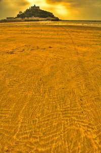
St Michael's Mount is a tidal island located 366 m off the Mount's Bay coast of Cornwall. ..
Videos provided by Youtube are under the copyright of their owners.
Interesting facts about this location
Varfell
Varfell is a hamlet within the parish of Ludgvan, Cornwall, UK. Varfell was formerly the ancestral home of chemist Humphry Davy. Varfell is now one the centres of production for the large flower and bulb growers Winchester Bulbs. Varfell Farm is the world's largest producers of daffodil bulbs.
Located at 50.14 -5.49 (Lat./Long.); Less than 2 km away
Crowlas
Crowlas is a village in Cornwall, England, United Kingdom. It is situated on the A30 about three miles east of Penzance and forms a small conurbation with Ludgvan "Lower Quarter", within the parish of the same name. The hamlet of Whitecross lies to the north.
Located at 50.15 -5.48 (Lat./Long.); Less than 2 km away
Ludgvan
Ludgvan is a civil parish and village in Cornwall, England, United Kingdom. The village is 2+⁄2 miles northeast of Penzance. The parish includes the villages of Ludgvan, Crowlas, Canon's Town and Long Rock. It is bounded by the parishes of Towednack and Lelant to the north, Madron and Penzance to the west, by St Erth, St Hilary and Marazion to the east and by the sea to the south. For the purposes of local government, Ludgvan elects a parish council every four years.
Located at 50.14 -5.49 (Lat./Long.); Less than 2 km away
Goldsithney
Goldsithney (Cornish: Golsydhni, meaning fair of St Sithney) is a village in west Cornwall, England, United Kingdom. It is on the A394 road at grid reference SW546306, about four miles (6 km) east of Penzance and one mile (1.6 km) east of Marazion. It is in the civil parish of Perranuthnoe. The centre of Goldsithney is a conservation area and has two pubs (the Trevelyan Arms and the Crown Inn), a shop, a gallery and a post office. The village holds a Charter fair in August each year.
Located at 50.13 -5.43 (Lat./Long.); Less than 3 km away
Chyandour
Chyandour (Cornish: Chi an Dowr, meaning "house of the water") is a small settlement within in the parish of Penzance in west Cornwall, England, United Kingdom. It is on the north-east edge of the town straddling the A30 trunk road. Historically Chyandour was one of the boundaries of the Borough of Penzance, and was the site of large tin smelting works.
Located at 50.13 -5.53 (Lat./Long.); Less than 4 km away
Pictures
Related Locations
Information of geographic nature is based on public data provided by geonames.org, CIA world facts book, Unesco, DBpedia and wikipedia. Weather is based on NOAA GFS.


