
Explore Plouye in France
Plouye in the region of Bretagne with its 707 inhabitants is a place in France - some 280 mi or ( 451 km ) West of Paris , the country's capital city .
Time in Plouye is now 07:27 AM (Sunday) . The local timezone is named " Europe/Paris " with a UTC offset of 1 hours. Depending on your budget, these more prominent locations might be interesting for you: Oxford, London, Cambridge, Bristol, and Vannes. Since you are here already, consider visiting Oxford . We saw some hobby film on the internet . Scroll down to see the most favourite one or select the video collection in the navigation. Where to go and what to see in Plouye ? We have collected some references on our attractions page.
Videos
Huelgoat centre bretagne hiver février 2011
Huelgoat Finistère centre bretagne hiver février 2011 ..
Driving Along Rue des Cieux & Place Aristide Briand D14, Huelgoat, Brittany 12th April 2010
Driving along Rue des Cieux & Place Aristide Briand (D14), Huelgoat, Finistere, Brittany, France Videoed on Monday,12th April 2010 Playlist: www.youtube.com ..
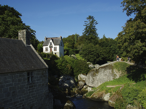
The Gorge At Huelgoat, Finistère, Brittany, France 12th April 2010
The Gorge At Huelgoat, Finistère, Brittany, France 12th April 2010 ..
Driving Along Rue des Cieux D14, Huelgoat, Finistère, Brittany, France 12th April 2010
Driving along Rue des Cieux (D14), Huelgoat, Finistere, Brittany, France Videoed on Monday,12th April 2010 Playlist: www.youtube.com ..
Videos provided by Youtube are under the copyright of their owners.
Interesting facts about this location
Réservoir Saint-Michel
Réservoir Saint-Michel is a lake in Finistère, France. At an elevation of 227 m, its surface area is 4.5 km².
Located at 48.35 -3.90 (Lat./Long.); Less than 13 km away
Gare de Carhaix
Gare de Carhaix is a railway station serving the town Carhaix-Plouguer, Finistère department, western France. The station was the hub of the Réseau Breton.
Located at 48.28 -3.56 (Lat./Long.); Less than 13 km away
Vieilles Charrues Festival
The Vieilles Charrues Festival is held every year in mid-July in the city of Carhaix located in the west of Brittany, France. This festival is the largest music festival in France, attracting more than 200,000 festival-goers every year (270,000 in 2011). This festival was created in 1992 in Landeleau, a small village in central Finistère. At that time, less than 500 revellers attended and the festival was more like a private party.
Located at 48.27 -3.56 (Lat./Long.); Less than 14 km away
Jardin botanique des Montagnes Noires
The Jardin botanique des Montagnes Noires (6 hectares) is a botanical garden specializing in conifers, located in Le Fell, Spezet, Finistère, Brittany, France. It is open daily; an admission fee is charged. The garden was established in 1995 and dedicated primarily to conifers. It currently contains about 700 species in total, including 500 conifer taxa as well as bamboos, camellias, heather, magnolias, rhododendrons, and roses.
Located at 48.18 -3.73 (Lat./Long.); Less than 16 km away
Goariva
Goariva is a village in the Carhaix-Plouguer commune in the Finistère department in north-western France.
Located at 48.26 -3.53 (Lat./Long.); Less than 16 km away
Pictures
Related Locations
Information of geographic nature is based on public data provided by geonames.org, CIA world facts book, Unesco, DBpedia and wikipedia. Weather is based on NOAA GFS.