-
You are here:
- Homepage »
- France »
- Ile-de-France » Champdeuil

Champdeuil Destination Guide
Explore Champdeuil in France
Champdeuil in the region of Île-de-France with its 723 inhabitants is a town in France - some 24 mi or ( 38 km ) South-East of Paris , the country's capital city .
Current time in Champdeuil is now 01:44 AM (Thursday) . The local timezone is named " Europe/Paris " with a UTC offset of 1 hours. Depending on the availability of means of transportation, these more prominent locations might be interesting for you: London, The Hague, Haarlem, Amsterdam, and Brussels. Since you are here already, make sure to check out London . We saw some video on the web . Scroll down to see the most favourite one or select the video collection in the navigation. Where to go and what to see in Champdeuil ? We have collected some references on our attractions page.
Videos
La Festa di Disneyland Resort Paris è...ora!
La prima destinazione turistica d'Europa compie 15 anni! ..
DESERT DU SUD MAROCAIN
UN VOYAGE AU DESERT MAROCAIN C EST MAGIQUE !!! ..
141 TB 407 de l'AJECTA à Verneuil l'Etang
La 141 TB 407 amène la rame AJECTA de Longueville à Paris le 3 mai 2007 pour qu'elle participe au "Mistral Express" ..
Le Bréguet de Chaubuisson
L'aérodrome de Fontenay-Trésigny en Seine-et-Marne possède une particularité étonnante : un Bréguet deux ponts y séjourne à temps complet... Dedans, un restaurant accueillant agréablement décoré. Voil ..
Videos provided by Youtube are under the copyright of their owners.
Interesting facts about this location
Melun Villaroche Aerodrome
For the unit of air flow measurement, see LFPM Melun Villaroche AerodromeAérodrome de Melun VillarocheAdvanced Landing Ground (ALG) A-55 IATA: none – ICAO: LFPM Summary Airport type Public Operator SYMPAV (Syndicat Mixte du pôle d'activités de Villaroche) Serves Melun, France Elevation AMSL 304 ft / 93 m Coordinates {{#invoke:Coordinates|coord}}{{#coordinates:48|36|19|N|002|40|15|E|region:FR_type:airport name= }} Map LFPM is located in FranceLFPMLFPM Runways Direction Length Surface m ft 10/28 1,975 6,480 Asphalt 01/19 1,300 4,265 Asphalt Sources: French AIP, UAF, DAFIF Melun Villaroche Aerodrome (French: Aérodrome de Melun Villaroche) is an aerodrome located 8.5 km north of Melun, a commune in the Seine-et-Marne department in the Île-de-France region in north-central France.
Located at 48.61 2.67 (Lat./Long.); Less than 5 km away
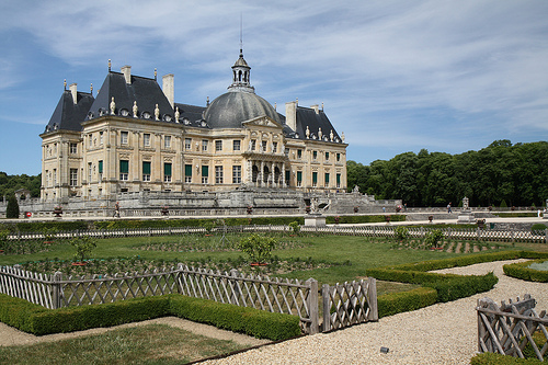
Vaux-le-Vicomte
The Château de Vaux-le-Vicomte is a baroque French château located in Maincy, near Melun, 55 km southeast of Paris in the Seine-et-Marne département of France. It was built from 1658 to 1661 for Nicolas Fouquet, Marquis de Belle Île, Viscount of Melun and Vaux, the superintendent of finances of Louis XIV. The château was an influential work of architecture in mid-17th century Europe.
Located at 48.56 2.71 (Lat./Long.); Less than 6 km away
Château de Blandy-les-Tours
The Château de Blandy-les-Tours is a medieval castle in the village of Blandy-les-Tours; it is about 5 km from the château de Vaux-le-Vicomte and 10 km from Melun. The castle is in the middle of the village. Its restoration began in 1992.
Located at 48.57 2.78 (Lat./Long.); Less than 7 km away
Gare de Verneuil-l'Étang
Verneuil-l'Étang is a railway station in Verneuil-l'Étang, Île-de-France, France.
Located at 48.65 2.83 (Lat./Long.); Less than 8 km away
Château de Grégy
The Château de Grègy is a château in Évry-Grégy-sur-Yerre, Seine-et-Marne, France. The first château was built in 1620 by Antoine de Brennes; two towers remain. Antoine de Clairambault rebuilt the central portion at the beginning of the 19th century, and added wings connecting the tower of a former church to the main building. American decorator and architect Ogden Codman, Jr. owned the château in the 20th century, adding its entry pavilions.
Located at 48.67 2.62 (Lat./Long.); Less than 10 km away
Pictures

Historical Weather
Related Locations
Information of geographic nature is based on public data provided by geonames.org, CIA world facts book, Unesco, DBpedia and wikipedia. Weather is based on NOAA GFS.