-
You are here:
- Homepage »
- Malta »
- Malta (general) » San Pawl il-Bahar

San Pawl il-Bahar Destination Guide
Discover San Pawl il-Bahar in Malta
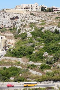
San Pawl il-Bahar in the region of Malta (general) with its 14,057 habitants is a town located in Malta - some 7 mi or ( 11 km ) North-West of Valletta , the country's capital .
Local time in San Pawl il-Bahar is now 05:06 AM (Sunday) . The local timezone is named " Europe/Malta " with a UTC offset of 1 hours. Depending on your flexibility, these larger cities might be interesting for you: Tripoli, Sousse, Vittoria, Syracuse, and Scicli. When in this area, you might want to check out Tripoli . We found some clip posted online . Scroll down to see the most favourite one or select the video collection in the navigation. Are you looking for some initial hints on what might be interesting in San Pawl il-Bahar ? We have collected some references on our attractions page.
Videos
Seafront Qawra Hotel and Resort Malta
Situated on the Qawra Coast road this top Qawra hotel offers spectacular views of the Mediterranean Sea. With its large pool area literally by the water's edge and surrounded by rocky beaches, this se ..
Diving with Tuna
Diving with Tuna with Oceandreams Gozo ..
Bugibba, Malta - Video Review
Bugibba is a small town with a big personality on the north east coast of Malta. bit.ly Forming part of St. Paul's Bay, alongside Qawra, it is the tourist hub of the island, attracting a fun-loving cr ..
Seashells Resort at Suncrest hotel Qawra Malta - hotel presentation
Seashells Resort at Suncrest hotel Qawra Malta - hotel presentation - for more information find us on the web: www.seashellsresortmalta.com ..
Videos provided by Youtube are under the copyright of their owners.
Interesting facts about this location
Qawra Tower
Qawra Tower is a fortification on the island of Malta built by the Knights of Malta in 1637. It is a small fortification, primarily a watchtower. It is also known locally as Fra Ben Tower. To the west it commands the entrance to St. Paul's Bay, to the east Salina Bay along with Għallis Tower. It was built during the reign of Grand Master Giovanni Paolo Lascaris and stands near the tip of Ras il-Qawra (Qawra Point). It is one of five Lascaris towers that he ordered be built.
Located at 35.96 14.42 (Lat./Long.); Less than 1 km away
Għallis Tower
Għallis Tower is a small coastal fortification that the Knights of Malta built on the island of Malta. It was originally primarily a watchtower with a garrison consisting of a bombardier and three gunners, who manned a three-pounder iron cannon. Construction took place during 1658 and 1659. The tower formed part of the chain of thirteen de Redin towers constructed during the reign of Grand Master Martin de Redin to allow communication from Gozo to the Knights' base at Grand Harbour.
Located at 35.95 14.43 (Lat./Long.); Less than 2 km away
St Paul's Island
St. Paul's Island (also referred to as Selmunett) is a small island close to Selmun near the north-east of the island of Malta. St. Paul's Island is sometimes split into two islands when the sea is rough. It has been uninhabited since the sole farmer abandoned his tiny dwelling and fields decades ago, thus making it the largest uninhabited island of Malta.
Located at 35.97 14.40 (Lat./Long.); Less than 2 km away
St. Mark's Tower
St. Mark's Tower or Qalet Marku is a fortification on the island of Malta built by the Knights of Malta. It is a small watchtower that stands on Qrejten Point on the north shore of Malta. St. Mark's Tower has sight of Għallis Tower to the west, and Madliena tower to the east. The tower still stands and appears to be in reasonable condition. It was one of the thirteen de Redin towers constructed during the reign of Grand Master Martin de Redin.
Located at 35.95 14.45 (Lat./Long.); Less than 3 km away
San Andrea School
The San Andrea School is a school in Malta. It was founded in 1992 at Sedqa, Independence Avenue, Naxxar by the Parents Foundation of Education (who also founded San Anton School). At the time it was composed of three classes. In 1995, the school was temporarily moved to a block of flats in Din L-Art Ħelwa.
Located at 35.92 14.39 (Lat./Long.); Less than 4 km away
Pictures
Historical Weather
Related Locations
Information of geographic nature is based on public data provided by geonames.org, CIA world facts book, Unesco, DBpedia and wikipedia. Weather is based on NOAA GFS.

