-
You are here:
- Homepage »
- Norway »
- Sogn og Fjordane » Hornindal

Hornindal Destination Guide
Explore Hornindal in Norway
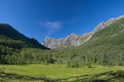
Hornindal in the region of Sogn og Fjordane is a town in Norway - some 201 mi or ( 323 km ) North-West of Oslo , the country's capital city .
Current time in Hornindal is now 01:26 PM (Tuesday) . The local timezone is named " Europe/Oslo " with a UTC offset of 1 hours. Depending on the availability of means of transportation, these more prominent locations might be interesting for you: Volda, Trondheim, Stavanger, Solvberg, and Naustdal. Since you are here already, make sure to check out Volda . We encountered some video on the web . Scroll down to see the most favourite one or select the video collection in the navigation. Where to go and what to see in Hornindal ? We have collected some references on our attractions page.
Videos
Fjord Helikopter - scenic flight Fjord Norway
The video is a breif presentation about helicopter scenic flights over the Nordfjord and Jostedal Glacier area executed by the company Helikopter Utleie AS based in Stryn, Norway. This flight is perfo ..
Norway. Travel. 2004.
..
Videos provided by Youtube are under the copyright of their owners.
Interesting facts about this location
Hornindalsvatnet
Hornindalsvatnet is Norway's and Europe's deepest lake, officially measured to a depth of 514 metres . Its surface is 53 metres above sea level, which means that its bottom is 461 metres below sea level. The village of Grodås lies at the eastern end of the lake in Hornindal and the village of Mogrenda is located on the western end of the lake in Eid. The E39 highway runs past Mogrenda and the lake.
Located at 61.93 6.35 (Lat./Long.); Less than 10 km away
Hornindalsrokken
Hornindalsrokken is a 1,529-metre tall mountain that is located on the border of the three municipalities of Stranda, Hornindal, and Ørsta. The mountain is sometimes also called Honndalsrokken or sometimes just Rokken or Rokkjen. The mountain is located about 14 kilometres northeast of the village of Grodås and lake Hornindalsvatnet in Hornindal. It is also located about 11 kilometres west of the village of Hellesylt in Stranda.
Located at 62.07 6.66 (Lat./Long.); Less than 14 km away
Storfjord (fjord)
The Storfjord (or Storfjorden) is a fjord in the Sunnmøre region, stretching from Hareid in the west to Tafjord and Geiranger east in Møre og Romsdal county, Norway. The Storfjord system includes the famous Geirangerfjord and Tafjorden, at small village of Stranda it branches off into Sunnylvsfjorden-Geirangerfjorden to the right and Norddalsfjorden-Tafjorden to the left.
Located at 62.15 6.58 (Lat./Long.); Less than 21 km away
Skårasalen
Skårasalen is a mountain in the municipality of Ørsta in Møre og Romsdal county, Norway. The 1,542-metre tall mountain has the seventh largest prominence of all mountains in Norway. The mountain is located about 5 kilometres south of the village of Sæbø and the Bondalen valley in the Hjørundfjord area of Ørsta. The nearby mountain, Jakta, lies directly to the east on the opposite side of the fjord.
Located at 62.17 6.49 (Lat./Long.); Less than 22 km away
Sunnmøre
Sunnmøre is the southernmost traditional district of the western Norwegian county of Møre og Romsdal. Its main city is Ålesund. The region comprises the municipalities of Giske, Hareid, Herøy, Norddal, Sande, Skodje, Haram, Stordal, Stranda, Sula, Sykkylven, Ulstein, Vanylven, Volda, Ørskog, Ørsta, and Ålesund. Though it is one of the three traditional districts in Møre og Romsdal, Sunnmøre is home to more than half the population of the county—with 130,601 of the 247,313 residents (53%).
Located at 62.15 6.33 (Lat./Long.); Less than 22 km away
Pictures


Historical Weather
Related Locations
Information of geographic nature is based on public data provided by geonames.org, CIA world facts book, Unesco, DBpedia and wikipedia. Weather is based on NOAA GFS.