-
You are here:
- Homepage »
- Spain »
- Castille and Leon » Peguerinos

Peguerinos Destination Guide
Discover Peguerinos in Spain
Peguerinos in the region of Castille and León with its 346 habitants is a town located in Spain - some 31 mi or ( 50 km ) North-West of Madrid , the country's capital .
Local time in Peguerinos is now 09:53 PM (Saturday) . The local timezone is named " Europe/Madrid " with a UTC offset of 1 hours. Depending on your flexibility, these larger cities might be interesting for you: Toledo, Valladolid, Valdemaqueda, San Rafael, and El Escorial. When in this area, you might want to check out Toledo . We found some clip posted online . Scroll down to see the most favourite one or select the video collection in the navigation. Are you looking for some initial hints on what might be interesting in Peguerinos ? We have collected some references on our attractions page.
Videos
Moteros Y Moteras - Cruz Verde to Galapagar Part 1
My friends Fernando, Sylvia and I riding from Cruz Verde to Galapagar in Madrid, Spain. This is part 1 of the journey which is a casual Sunday ride along the super twisty road that runs along the vall ..
Camara video
Prueba en moto y 4x4 de grabación de vídeo con una cámara Pentax Optio WS80. ..
Via Crucis Valle de los Caidos
..
Geocaching Arena 2012 trailer
Trailer del reportaje realizado por Comepiedras del Evento Geocaching Arena 2012 ..
Videos provided by Youtube are under the copyright of their owners.
Interesting facts about this location
Peguerinos
Peguerinos is a municipality located in the province of Ávila, Castile and León, Spain. According to the 2006 census, the municipality has a population of 318 inhabitants.
Located at 40.63 -4.23 (Lat./Long.); Less than 1 km away
Santa María de la Alameda
Santa María de la Alameda is a municipality of the Community of Madrid, Spain. It is linked to the city of Madrid and the town of El Escorial by regular train services. A popular weekend and holiday destination, Santa Maria is popular with anglers, hunters, walkers and outdoors enthusiasts.
Located at 40.60 -4.25 (Lat./Long.); Less than 3 km away
Dehesa de la Cepeda
Dehesa de la Cepeda is an exclave in central Spain. Legally part of Santa María de la Alameda, Madrid, it is geographically between the provinces of Ávila and Segovia in the autonomous community of Castile and León. It is mostly pasture.
Located at 40.67 -4.28 (Lat./Long.); Less than 6 km away
Francisco Franco
Francisco Franco y Bahamonde (4 December 1892 – 20 November 1975) was a Spanish military leader and statesman who ruled as the dictator of Spain from 1936 until his death. He came to power during the Spanish Civil War while serving as the Generalísimo of the Nationalist faction. Franco led the Nationalists to victory in the civil war and went on to become the longest ruling dictator in European history. Franco was from a military background.
Located at 40.64 -4.16 (Lat./Long.); Less than 7 km away
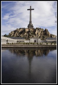
Valle de los Caídos
The Valle de los Caídos ("Valley of the Fallen") is a Catholic basilica and a monumental memorial in the municipality of San Lorenzo de El Escorial, erected at Cuelgamuros Valley in the Sierra de Guadarrama, near Madrid, conceived by Spanish dictator Francisco Franco to honour and bury those who fell during the Spanish Civil War. It was also claimed by Franco that the monument was meant to be a "national act of atonement" and reconciliation.
Located at 40.64 -4.16 (Lat./Long.); Less than 7 km away
Pictures
Related Locations
Information of geographic nature is based on public data provided by geonames.org, CIA world facts book, Unesco, DBpedia and wikipedia. Weather is based on NOAA GFS.

