-
You are here:
- Homepage »
- United Kingdom »
- England » Blean

Blean Destination Guide
Explore Blean in United Kingdom
Blean in the region of England with its 1,536 inhabitants is a town in United Kingdom - some 52 mi or ( 84 km ) East of London , the country's capital city .
Current time in Blean is now 08:09 PM (Thursday) . The local timezone is named " Europe/London " with a UTC offset of 0 hours. Depending on the availability of means of transportation, these more prominent locations might be interesting for you: Wye, Wootton, Thannington, London, and Leysdown-on-Sea. Since you are here already, make sure to check out Wye . We encountered some video on the web . Scroll down to see the most favourite one or select the video collection in the navigation. Where to go and what to see in Blean ? We have collected some references on our attractions page.
Videos
Metal Gear Awesome Is Not On Newgrounds.com!! (YouTube poop)
Yeah, it's a poop lolz. I'm not the best but i wanted to give it a try O: and yeah, it's on Newgrounds.com it shouldn't be on YouTube. But hey, it's a joke ..
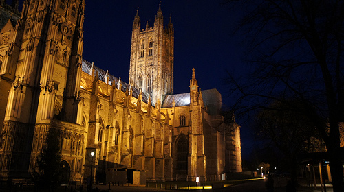
Canterbury, England
Canterbury is a beautiful medieval town with a great Cathedral. St. Augustine, the first Archbishop of Canterbury, founded a church there in 597. The cathedral became a major pilgimage site after Knig ..
Visiting Canterbury England
Canterbury is a wonderful city in the region of Kent, set in the area well known as "The Gardens of England" for his beautiful vegetation, flowers, and nice weather. If you fly to any of the Internati ..
Sheerness to Whitstable Motorway M2 England
Timelapse drive from Sheerness A249 along the M2 Motorway and A299 to Whitstable finishing at the Health Centre ..
Videos provided by Youtube are under the copyright of their owners.
Interesting facts about this location
Canterbury (UK Parliament constituency)
Canterbury is a constituency represented in the House of Commons of the UK Parliament since 1987 by Julian Brazier of the Conservative Party.
Located at 51.30 1.05 (Lat./Long.); Less than 1 km away
University of Kent
The University of Kent (formerly the University of Kent at Canterbury, abbreviated as Cantuar. for post-nominals) is a public research university based in Kent, United Kingdom. It was founded in 1965 and is recognised as a British "plate glass university". It is a member of the Santander Network of European universities encouraging social and economic development,Association of Commonwealth Universities and Universities UK.
Located at 51.30 1.07 (Lat./Long.); Less than 2 km away
Archbishop's School
Archbishops School is a mixed-ability Church of England secondary school situated in Canterbury, Kent in the United Kingdom. It is a school for pupils and students of all abilities from the ages of 11 to 19 and has approximately 850 pupils. The school is situated on a parkland site on the outskirts of Canterbury. Although the school celebrated its 50th anniversary in the 2007-08 academic year, it has only seen three headmasters in that time.
Located at 51.29 1.07 (Lat./Long.); Less than 3 km away
St. Dunstan's, Canterbury
St. Dunstan's is a church dedicated to St. Dunstan in Canterbury, Kent, slightly out of the city centre. The parish has been held in plurality with others nearby at different times, in a way that is confusing and difficult to document. In 2010 the parish was joined with the parishes of the City Centre Parish in a new pastoral grouping, City Centre with St. Dunstan.
Located at 51.28 1.07 (Lat./Long.); Less than 3 km away
Canterbury West railway station
Canterbury West railway station is one of two stations in Canterbury in Kent, England. It is north-northwest of the city centre. It is served by Southeastern. Although called Canterbury West the station is about ½ a mile due north of Canterbury East station, and only about twenty yards to its west. The station and its line was built by the South Eastern Railway, while Canterbury East was built by the London, Chatham and Dover Railway.
Located at 51.28 1.08 (Lat./Long.); Less than 3 km away
Pictures
Historical Weather
Related Locations
Information of geographic nature is based on public data provided by geonames.org, CIA world facts book, Unesco, DBpedia and wikipedia. Weather is based on NOAA GFS.