-
You are here:
- Homepage »
- United Kingdom »
- England » Pangbourne

Pangbourne Destination Guide
Delve into Pangbourne in United Kingdom
Pangbourne in the region of England with its 3,822 residents is a city in United Kingdom - some 41 mi or ( 66 km ) West of London , the country's capital .
Current time in Pangbourne is now 12:30 PM (Friday) . The local timezone is named " Europe/London " with a UTC offset of 0 hours. Depending on your travel modalities, these larger destinations might be interesting for you: Wolverhampton, Whitchurch, Wallingford, Sulhampstead, and Streatley. While being here, make sure to check out Wolverhampton . We encountered some video on the web . Scroll down to see the most favourite one or select the video collection in the navigation. Are you curious about the possible sightseeing spots and facts in Pangbourne ? We have collected some references on our attractions page.
Videos
Sportfish Reading - Take a look at our store & annual show!
Take a glance around our store in Reading, Berkshire. Plus the best free to enter fly fishing show in the south east held at Sportfish Reading Store annually! The 2013 show will be held on the weekend ..
UKWCT Open Day - May 2010
Some footage of the wolves at the UK Wolf Conservation Trust filmed during the May Bank Holiday Open Day on 31st May, 2010. ..
Trouble at Travellodge
www.hellyerspuppetworkshop.blogspot.com So we checked into our room and discovered there was a door which lead into the ajoining conference room... it was locked. As we left our room to go and get som ..
70000 Britannia, VSOE London to Bristol 12 Oct 2011
Preserved ex-BR Britannia Class pacific 4-6-2 no 70000 "Britannia" pulls the VSOE British Pullman from London to Bristol on 12th October 2011. The train is seen on the ex-GWR Berks and Hants Line, pas ..
Videos provided by Youtube are under the copyright of their owners.
Interesting facts about this location
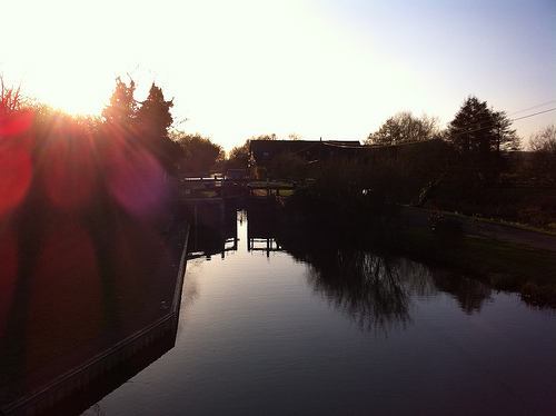
River Pang
The River Pang is a small chalk stream river in the west of the English county of Berkshire, and a tributary of the River Thames. It runs for approximately 23 kilometres from its source near the village of Compton to its confluence with the Thames in the village of Pangbourne. The river, and its water voles, are thought to have inspired author Kenneth Grahame's character Ratty and his book The Wind in the Willows.
Located at 51.49 -1.09 (Lat./Long.); Less than 0 km away
Whitchurch Bridge
Whitchurch Bridge is a toll road bridge over the River Thames in England. It carries the road between the villages of Pangbourne, Berkshire, and Whitchurch-on-Thames, Oxfordshire, and crosses the river on the reach above Mapledurham Lock, just before Whitchurch Lock. The bridge has a weight limit of 7.5 tonnes.
Located at 51.49 -1.09 (Lat./Long.); Less than 0 km away
Whitchurch Lock
Whitchurch Lock is a lock and weir situated on the River Thames in England. It is a pound lock, built by the Thames Navigation Commissioners in 1787. It is on an island near the Oxfordshire village of Whitchurch-on-Thames and is inaccessible except by boat. The weir crosses the river to the Berkshire village of Pangbourne .
Located at 51.49 -1.09 (Lat./Long.); Less than 0 km away
Denefield School
Denefield School is a secondary school located in Tilehurst, Reading, Berkshire, England. Originally called Long Lane Comprehensive school after its location, Its name was later changed to avoid confusion with a primary school of the same name. The school was founded in 1976 and opened with 180 students in Year 7. The Sixth form took its first students in 1981. Since then Denefield has continued to grow, with approximately 1,200 students attending during the 2005-2006 school year.
Located at 51.47 -1.06 (Lat./Long.); Less than 2 km away
Goring Rural District
Goring was a rural district in Oxfordshire, England from 1894 to 1932. It was formed from that part of the Bradfield rural sanitary district which was in Oxfordshire, with the Berkshire part going to the Bradfield Rural District. It consisted of the three parishes of Goring, Mapledurham and Whitchurch. The district was abolished in 1932 under a County Review Order, the parishes becoming part of the Henley Rural District.
Located at 51.51 -1.09 (Lat./Long.); Less than 3 km away
Pictures


Related Locations
Information of geographic nature is based on public data provided by geonames.org, CIA world facts book, Unesco, DBpedia and wikipedia. Weather is based on NOAA GFS.