-
You are here:
- Homepage »
- United Kingdom »
- England » Swavesey

Swavesey Destination Guide
Touring Swavesey in United Kingdom
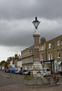
Swavesey in the region of England with its 2,535 citizens is a city located in United Kingdom - some 55 mi or ( 89 km ) North of London , the country's capital city .
Time in Swavesey is now 12:28 AM (Tuesday) . The local timezone is named " Europe/London " with a UTC offset of 0 hours. Depending on your travel resources, these more prominent places might be interesting for you: Willingham, Warboys, Upwood, Reading, and Peterborough. Being here already, consider visiting Willingham . We collected some hobby film on the internet . Scroll down to see the most favourite one or select the video collection in the navigation. Check out our recommendations for Swavesey ? We have collected some references on our attractions page.
Videos
St Ives to Cambridge Railway (fast version)
A high speed walk along the St Ives railway between Fen Drayton and Cambridge. See the rails for the last time, before the dreaded guided busway takes them away for ever. The journey passes through Lo ..
Cambridge to St Ives (Mis?) Guided Busway in first week of opening
The New Cambridge to St Ives Guided Busway in operation in its first week open to the public. Overdue, Overbudget and involving the destruction of a perfectly good railway line, but worth a visit to l ..
MGB Around The Sea. Setting off from the MGOC, Swavesey
www.mgbaroundthesea.com http www.mgownersclub.co.uk The MGOC can be contacted on Cambridge 01954 231125 Today at 12 a 1969 MGB Roadster set off on an epic 5300 mile journey. The trip - which has been ..
Lake & river walk - Part 1
This is part 1 (of 7) short videos showing one of the walks around Fen Drayton RSPB reserve that also encompasses parts of the Great Ouse and the Cambridge to St Ives guided busway. It's part vlog and ..
Videos provided by Youtube are under the copyright of their owners.
Interesting facts about this location
Swavesey Rural District
Swavesey was a rural district in Cambridgeshire, England, from 1894 to 1934. It was formed under the Local Government Act 1894 from the part of the St Ives rural sanitary district which was in Cambridgeshire (the rest being in Huntingdonshire). It covered the civil parishes of Boxworth Conington Fen Drayton Lolworth Over Swavesey It was merged in 1934 under a County Review Order into the Chesterton Rural District. It now forms part of the South Cambridgeshire district.
Located at 52.30 0.00 (Lat./Long.); Less than 1 km away
Cambridgeshire
Cambridgeshire is a county in England, bordering Lincolnshire to the north, Norfolk to the northeast, Suffolk to the east, Essex and Hertfordshire to the south, and Bedfordshire and Northamptonshire to the west. The city of Cambridge is the county town. Modern Cambridgeshire was formed from the historic counties of Cambridgeshire and Huntingdonshire, together with the Isle of Ely and the Soke of Peterborough; it contains most of the region known as Silicon Fen.
Located at 52.33 0.00 (Lat./Long.); Less than 4 km away
Long Stanton railway station
Long Stanton railway station was a station on the Great Eastern Railway, between Cambridge and Huntingdon. It served the villages of Longstanton and Willingham (being roughly midway between them), until closure in October 1970. The station was immortalised in 1964 in the song "Slow Train" by Flanders and Swann.
Located at 52.29 0.05 (Lat./Long.); Less than 4 km away
New Bedford River
The New Bedford River, also known as the Hundred Foot Drain because of the distance between the tops of the two embankments on either side of the river, is a man-made cut-off or by-pass channel of the River Great Ouse in the Fens of Cambridgeshire, England. It provides an almost straight channel between Earith and Denver Sluices. It is tidal, with reverse tidal flow being clearly visible at Welney, some 19 miles from the sea.
Located at 52.33 0.03 (Lat./Long.); Less than 4 km away
Golden Lion (pub)
The Golden Lion in St Ives, Cambridgeshire is a former coaching inn, now more known as a pub and popular night spot and for alleged ghost sightings. The pub dates back to 1605 though it has been renovated many times since.
Located at 52.32 -0.07 (Lat./Long.); Less than 5 km away
Pictures
Historical Weather
Related Locations
Information of geographic nature is based on public data provided by geonames.org, CIA world facts book, Unesco, DBpedia and wikipedia. Weather is based on NOAA GFS.


