-
You are here:
- Homepage »
- United States »
- California » Dana Point

Dana Point Destination Guide
Delve into Dana Point in United States
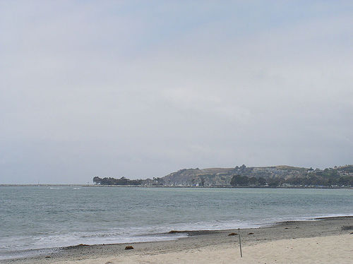
Dana Point in the region of California with its 33,351 residents is located in United States - some 2,279 mi or ( 3668 km ) West of Washington , the country's capital .
Local time in Dana Point is now 05:14 PM (Saturday) . The local timezone is named " America/Los Angeles " with a UTC offset of -7 hours. Depending on your mobility, these larger destinations might be interesting for you: Aliso Viejo, Bakersfield, Beachwood Trailer Park, Capistrano Beach, and Coto De Caza. While being here, you might want to check out Aliso Viejo . We discovered some clip posted online . Scroll down to see the most favourite one or select the video collection in the navigation. Are you curious about the possible sightseeing spots and facts in Dana Point ? We have collected some references on our attractions page.
Videos
Giant Fin Whale Mugs Whale Watching Passengers!
On Sunday whale watching passengers got the show of a lifetime when a fin whale "mugged" (circled very closely) our catamaran repeatedly within one to two miles of Dana Point Harbor, California. Fin w ..
The Future of Laguna Cliffs Resort & Spa, A Marriott Resort
The Future Laguna Cliffs Resort & Spa! ..
Whale Watching Dana Point Visitors | Only $15!
Whale Watching Dana Point | Visit www.newportwhales.com for special offers! Get ready to partake on an wondrous adventure (Whale Watching Dana Point) departing from the sunny coast of Newport Beach! B ..
So-Cal Nor'Sea 27 Sail-in & Get-Together
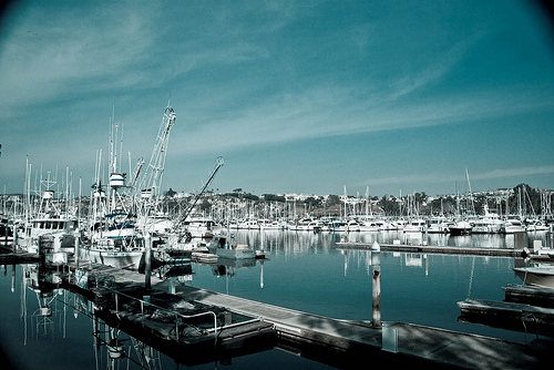
This video is of the 2011 So-Cal Nor'Sea 27 Sail in to Dana Point Marina, in Dana Point California. 4 Nor'Sea 27 boats sailed in to the guest slips. Many more owners drove in. Even a few non-owners ma ..
Videos provided by Youtube are under the copyright of their owners.
Interesting facts about this location
Coastland University
Coastland University (also known as Coastland Christian Bible College and University) began holding classes in 1999. It is a non-denominational, co-educational institution located in Southern California that uses classroom space at area churches and other venues rather than a dedicated campus.
Located at 33.47 -117.70 (Lat./Long.); Less than 0 km away
Dana Hills High School
Dana Hills High School is a high school in Dana Point, California. It is one of the oldest high schools in South Orange County, having opened in 1973. The school's enrollment of 3,000 students is drawn from the nearby communities of Laguna Niguel, Dana Point, Capistrano Beach, and San Juan Capistrano. Dana Hills now has over 155,839 square feet in permanent buildings, yet it still struggles with overcrowding.
Located at 33.48 -117.70 (Lat./Long.); Less than 1 km away
Capistrano Beach, Dana Point, California
Capistrano Beach, also known as Capo Beach, is part of the city of Dana Point in Orange County, California. It is bordered by San Clemente to the south and Laguna Beach to the north. Capistrano Beach is one of the few remaining "beach towns" in Orange County. It has avoided much of the commercialization of the surrounding areas, and remains a unique and charming place with a "small town" atmosphere. Capistrano Beach is situated along the coast on the southern end of Dana Point.
Located at 33.46 -117.68 (Lat./Long.); Less than 2 km away
El Adobe de Capistrano
El Adobe de Capistrano, or simply known as El Adobe, is a restaurant located in San Juan Capistrano, California. It has been operated since 1948 and is in a building composed of two historic adobes near Mission San Juan Capistrano. It is also famous for being frequented by and being a favorite of U.S. President Richard Nixon who lived in nearby San Clemente. The adobe which comprises the northern portion of the restaurant was built as the home of Miguel Yorba in 1797.
Located at 33.50 -117.66 (Lat./Long.); Less than 5 km away
San Juan Capistrano, California
San Juan Capistrano is a city in southern Orange County, California, located approximately 23 miles southeast of Downtown Santa Ana. The current OMB metropolitan designation for San Juan Capistrano and the Orange County Area is “Santa Ana-Anaheim-Irvine, CA. ” The population was 34,593 at the 2010 census, up from 33,826 at the 2000 census. The city was created around Mission San Juan Capistrano, and many of the homes and strip malls resemble the Spanish architecture that compose the building.
Located at 33.50 -117.66 (Lat./Long.); Less than 5 km away
Pictures


Related Locations
Information of geographic nature is based on public data provided by geonames.org, CIA world facts book, Unesco, DBpedia and wikipedia. Weather is based on NOAA GFS.