Explore Tulla in Ireland
Tulla in the region of Munster is a town in Ireland - some 109 mi or ( 176 km ) West of Dublin , the country's capital city .
Current time in Tulla is now 04:18 AM (Monday) . The local timezone is named " Europe/Dublin " with a UTC offset of 0 hours. Depending on the availability of means of transportation, these more prominent locations might be interesting for you: Truro, Derry, Belfast, Tubber, and Tralee. Since you are here already, make sure to check out Truro . We saw some video on the web . Scroll down to see the most favourite one or select the video collection in the navigation. Where to go and what to see in Tulla ? We have collected some references on our attractions page.
Videos
Irlande 2009
Quelques souvenirs de notre voyage en Irlande à Paques 2009 ..
Knappogue Castle Wedding Fair 2011
Took place on Sunday 4th December 2011. Knappogue Castle is the ideal venue for your wedding. The castle also has accommodation for a limited number of guests. For more information please visit www.sh ..
2012 Ireland Trip Part 2 - Craggaunowen
In which I visit Craggaunowen Castle & Crannóg, local fauna are documented, cuss words are said (sorry), math is poorly done (the actual approximate cost of a gallon of gas in Ireland turns out to be ..
Mooghaun Heritage Day 2012
Bronze Age Hillfort in Newmarket-on-Fergus ..
Videos provided by Youtube are under the copyright of their owners.
Interesting facts about this location
Craggaunowen Castle
Craggaunowen Castle, built in 1550, is a fortified tower house located near Sixmilebridge, County Clare, Ireland. It was built by John MacSioda MacNamara, a descendent of Sioda MacNamara, who built Knappogue Castle in 1467. It stands on a crag overlooking the lake in the grounds of Craggaunowen Park, off the N18 Limerick / Galway road, ten kilometres east of Quin, County Clare.
Located at 52.81 -8.79 (Lat./Long.); Less than 6 km away
Kilkishen
Kilkishen is a village in southeast County Clare, Ireland. The village is 8 kilometres east of Quin and 14 kilometres north of Shannon.
Located at 52.81 -8.74 (Lat./Long.); Less than 7 km away
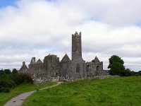
Quin Abbey
Quin Abbey, in Quin, County Clare, Ireland, was built between 1402 and 1433 by Sioda Cam MacNamara, for Fathers Purcell and Mooney, friars of the Franciscan order. Although mostly roofless, the structure of the abbey is relatively well preserved. There is an intact cloister, and many other surviving architectural features make the abbey of significant historical value. A far earlier monastery had existed on the site, which burned down in 1278.
Located at 52.82 -8.86 (Lat./Long.); Less than 9 km away
Quin, County Clare
Quin (Irish: Cuinche, meaning "five ways") is a village in southeast County Clare in Ireland. The village's main attraction, Quin Abbey, is open to the public, and although mostly ruined, much of the structure remains. The abbey was built on the foundations of an earlier Norman castle, and the foundations of its corner towers can still be seen. The name of the village is a reference in ancient Irish to the original five roads out of the village. The River Rine runs through Quin.
Located at 52.82 -8.87 (Lat./Long.); Less than 9 km away
Knappogue Castle
The Knappogue Castle & Walled Garden, built in 1467, is located in County Clare, Ireland. It was built by Seán Mac Conmara, and is a good example of a medieval tower house. It has a long and varied history, from a battlefield to a dwelling place. In 1571 the castle became the seat of the Mac Conmara sept, the Earls of West Clancullen. Donnchadh Mac Conmara was a leader of the Irish Rebellion of 1641 and Knappogue remained in Mac Conmara hands throughout the Irish Confederate Wars of the 1640s.
Located at 52.79 -8.83 (Lat./Long.); Less than 9 km away
Pictures
Related Locations
Information of geographic nature is based on public data provided by geonames.org, CIA world facts book, Unesco, DBpedia and wikipedia. Weather is based on NOAA GFS.


