-
You are here:
- Homepage »
- Palestinian Territory »
- Palestinian Territory (general) » Khallat an Nu'man

Khallat an Nu'man Destination Guide
Delve into Khallat an Nu'man in Palestinian Territory
Khallat an Nu'man in the region of Palestinian Territory (general) with its 1,397 residents is located in Palestinian Territory - some 315 mi or ( 507 km ) South-East of East Jerusalem , the country's capital .
Local time in Khallat an Nu'man is now 05:55 AM (Wednesday) . The local timezone is named " Asia/Hebron " with a UTC offset of 2 hours. Depending on your mobility, these larger destinations might be interesting for you: Nicosia, Damascus, Amman, Tyre, and Beirut. While being here, you might want to check out Nicosia . We discovered some clip posted online . Scroll down to see the most favourite one or select the video collection in the navigation. Are you curious about the possible sightseeing spots and facts in Khallat an Nu'man ? We have collected some references on our attractions page.
Videos
Travel Palestine - Rediscover Your Senses
This video shares the treasures of Palestine, its remarkable cultural and natural heritage and the spirit of the people. The video is property of the Palestinian Ministry of Tourism & Antiquities and ..
From Palestine on Christmas
Justice is possible and hope is justified. ..
Beit Sahour, A Living Heritage
"Beit Sahour, a living heritage" is a short film about Beit Sahour, the town of the Shepherds' Field. The film is produced by Beit Sahour Municipality, and is made by the Video Production Unit of the ..
Arab Womens Union
Best place to buy Palestinian Embroidery in Bethlehem ..
Videos provided by Youtube are under the copyright of their owners.
Interesting facts about this location
Umm Tuba
Umm Tuba is an Arab neighborhood in East Jerusalem part of Sur Baher; it is northeast of Har Homa and Bethlehem, and southeast of Kibbutz Ramat Rachel. It has a population of 4,000. After the 1967 Six-Day War, Umm Tuba was incorporated into the municipal district of Jerusalem. Based on archaeological finds, Umm Tuba was the site of the biblical city of Netophah.
Located at 31.73 35.23 (Lat./Long.); Less than 2 km away
Har Homa
Har Homa is a neighborhood in southern East Jerusalem, near Beit Sahour. Built on land annexed to the Jerusalem municipality by Israel after the 1967 Six-Day War, it is considered by much of the world an illegal Israeli settlement, although Israel disputes this. The neighborhood was officially renamed Homat Shmuel in 1998 after Shmuel Meir, a former deputy mayor of Jerusalem, who played an active role in its development before he was killed in a car accident in 1996.
Located at 31.73 35.22 (Lat./Long.); Less than 2 km away
Siege of the Church of the Nativity in Bethlehem
The Siege of the Church of the Nativity in Bethlehem lasted from April 2 to May 10, 2002 in Bethlehem in the West Bank. As part of Operation Defensive Shield, the Israel Defense Forces (IDF) occupied Bethlehem and tried to capture wanted Palestinian militants. Dozens of them fled into the Church of the Nativity and sought refuge. Further more, there were some 200 monks and other Palestinians who arrived at the site for different reasons, and were held as hostages by the gunmen.
Located at 31.70 35.21 (Lat./Long.); Less than 4 km away
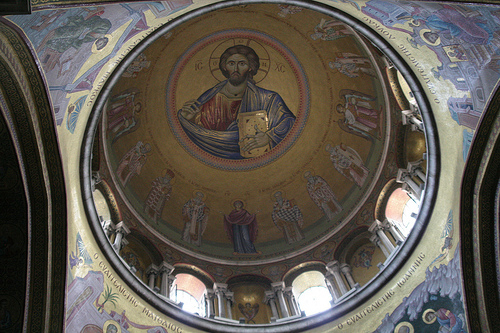
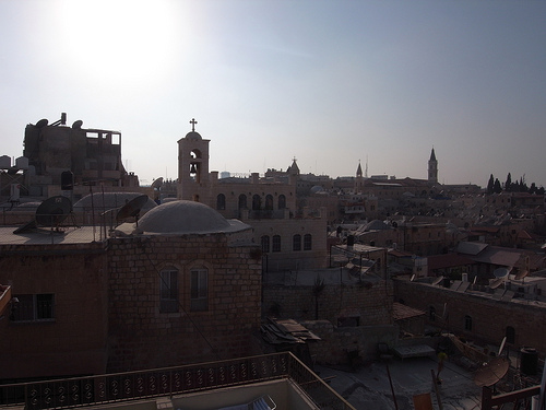
Church of the Nativity
The Church of the Nativity is a basilica located in Bethlehem, Palestinian territories. The church was originally commissioned in 327 AD by Constantine and his mother Helena over the site that is still traditionally considered to be located over the cave that marks the birthplace of Jesus of Nazareth. The Church of the Nativity site's original basilica was completed in 339 AD and destroyed by fire during the Samaritan Revolts in the sixth century AD.
Located at 31.70 35.21 (Lat./Long.); Less than 4 km away
Manger Square
Manger Square is an important city square in the center of Bethlehem. It takes its name from the manger where Jesus is said to have been born which, according to Christian dogma, is in the Church of the Nativity, possibly the oldest existing church in the world, which surrounds the square. Also around Manger Square is the Mosque of Omar (the city's only mosque) and the Palestinian Peace Center.
Located at 31.70 35.21 (Lat./Long.); Less than 4 km away
Pictures


Historical Weather
Related Locations

Information of geographic nature is based on public data provided by geonames.org, CIA world facts book, Unesco, DBpedia and wikipedia. Weather is based on NOAA GFS.