-
You are here:
- Homepage »
- United Kingdom »
- Scotland » Earlston

Earlston Destination Guide
Discover Earlston in United Kingdom
Earlston in the region of Scotland with its 1,728 habitants is a town located in United Kingdom - some 304 mi or ( 489 km ) North of London , the country's capital .
Local time in Earlston is now 06:49 PM (Friday) . The local timezone is named " Europe/London " with a UTC offset of 0 hours. Depending on your flexibility, these larger cities might be interesting for you: Stirling, Smailholm, Sheffield, Perth, and Oxton. When in this area, you might want to check out Stirling . We found some clip posted online . Scroll down to see the most favourite one or select the video collection in the navigation. Are you looking for some initial hints on what might be interesting in Earlston ? We have collected some references on our attractions page.
Videos
Kayaking the Tweed River
Sarah D, Dudo and Cygnet Sam paddle from Innerleithen to Kelso. ..
Bagpipe Band Competition
Macgellan video "Dram" from St. Boswell's England featuring Bagpipe Band Competition -- August 18, 2007 -- www.Macgellan.com ..
The Mill House, nr Earlston, Melrose, Scottish Borders self catering holiday accommodation
Is a quite spectacular conversion of an old farm steading, wonderfully bright and spacious, and luxuriously appointed to provide the very best in holiday letting accommodation. It is situated on a hil ..
The Designer's House, Melrose, Scottish Borders - Self catering Accommodation Scotland
It is called the Designer's House for good reason, for the professional owner has invested all her skill in adorning this jewel of a cottage on the outskirts of the pretty town of Melrose in the lovel ..
Videos provided by Youtube are under the copyright of their owners.
Interesting facts about this location
Earlston High School
Earlston High School is a secondary school in Earlston, Scottish Borders. It serves Earlston, as well as the surrounding area. It is in the middle of Earlston, off the A68 road. A new school building was completed in 2009.
Located at 55.64 -2.66 (Lat./Long.); Less than 1 km away
River Leader
The River Leader, or Leader Water, is a small tributary of the River Tweed in Lauderdale in the Scottish Borders. It flows southwards from the Lammermuir Hills through the towns of Lauder and Earlston, joining the River Tweed at Leaderfoot.
Located at 55.61 -2.67 (Lat./Long.); Less than 4 km away
Leaderfoot Viaduct
Leaderfoot Viaduct is a railway viaduct over the River Tweed in the Scottish Borders, Scotland. It is 2.5 km east of Melrose at grid reference NT574347. The viaduct was opened on 16 November 1863 to carry the Berwickshire Railway, which connected Reston with St Boswells (on the Edinburgh to Carlisle "Waverley Line"), via Duns and Greenlaw. The engineers of the railway were Charles Jopp and Wylie & Peddie.
Located at 55.60 -2.68 (Lat./Long.); Less than 4 km away
Scott's View
Scott's View refers to a viewpoint in the Scottish Borders, overlooking the valley of the River Tweed, which is reputed to be one of the favourite views of Sir Walter Scott. The viewpoint can be located directly from a minor road leading south from Earlston just off the A68 and by travelling north from the village of St. Boswells up the slope of Bemersyde Hill. The view is around 3 miles east of Melrose. The view is to the west, and is dominated by the three peaks of Eildon Hill.
Located at 55.60 -2.65 (Lat./Long.); Less than 5 km away
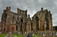
Melrose Abbey
Melrose Abbey is a Gothic-style abbey in Melrose, Scotland. It was founded in 1136 by Cistercian monks, on the request of King David I of Scotland. It was headed by the Abbot or Commendator of Melrose. Today the abbey is maintained by Historic Scotland (open all year; entrance charge). The east end of the abbey was completed in 1146. Other buildings in the complex were added over the next 50 years. The abbey was built in the form of a St. John's cross.
Located at 55.60 -2.72 (Lat./Long.); Less than 5 km away
Pictures
Related Locations
Information of geographic nature is based on public data provided by geonames.org, CIA world facts book, Unesco, DBpedia and wikipedia. Weather is based on NOAA GFS.

