-
You are here:
- Homepage »
- United States »
- California » Rancho Palos Verdes

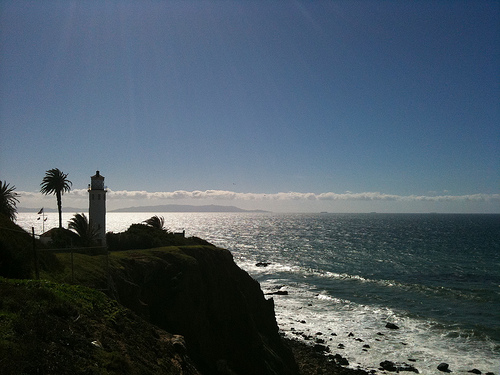
Rancho Palos Verdes Destination Guide
Explore Rancho Palos Verdes in United States
Rancho Palos Verdes in the region of California with its 41,643 inhabitants is a town in United States - some 2,309 mi or ( 3716 km ) West of Washington , the country's capital city .
Current time in Rancho Palos Verdes is now 08:31 PM (Friday) . The local timezone is named " America/Los Angeles " with a UTC offset of -7 hours. Depending on the availability of means of transportation, these more prominent locations might be interesting for you: Bakersfield, Carson, Fresno, Gardena, and Hermosa Beach. Since you are here already, make sure to check out Bakersfield . We encountered some video on the web . Scroll down to see the most favourite one or select the video collection in the navigation. Where to go and what to see in Rancho Palos Verdes ? We have collected some references on our attractions page.
Videos
Rancho Palos Verdes, California YouTube HD
Rancho Palos Verdes is one of the many counties that make up the greater Los Angeles area. Beautiful and laid back with estate sized properties, it is a world away from the freeways's and high rises t ..
Palos Verdes Estates - YouTube HD
Palos Verdes is a name often used to refer to a group of coastal cities in the Palos Verdes Hills on the Palos Verdes Peninsula, within southwestern Los Angeles County in the US state of California. W ..
Abalone Cove Tidepool Exploring
Southern California is known for its miles of sandy beaches. But many Angelinos may be less familiar with the rocky, rugged coastlines of Palos Verdes. Here is an excellent place to get outside and ex ..
30 Wayfarers Chapel
3 weeks RV tour beside the beaten track Part 30 of 30 Wayfarers Chapel US National Register of Historic Places Location: 5755 Palos Verdes Dr. S Rancho Palos Verdes, California Coordinates: 33°44′37.1 ..
Videos provided by Youtube are under the copyright of their owners.
Interesting facts about this location
Marineland of the Pacific
Marineland of the Pacific was a public oceanarium and tourist attraction located on the Palos Verdes Peninsula coast in Los Angeles County, California, USA. Architect William Pereira designed the main structure. It was also known as Hanna-Barbera's Marineland during the late 1970s and early 1980s. Marineland operated from 1954 until 1987, when it was purchased by the owners of SeaWorld San Diego.
Located at 33.74 -118.40 (Lat./Long.); Less than 1 km away
Portuguese Bend
The Portuguese Bend region is the largest area of natural vegetation remaining on the Palos Verdes Peninsula, in Los Angeles County, California. Though once slated for development (and in fact the projected route of Crenshaw Boulevard through the area still shows on many maps), the area is geologically unstable and is unsuitable for building.
Located at 33.75 -118.36 (Lat./Long.); Less than 2 km away
Rancho Palos Verdes, California
Rancho Palos Verdes (sometimes abbreviated RPV) is a city in Los Angeles County, California, that was incorporated on September 7, 1973. The population was 41,643 at the 2010 census. Rancho Palos Verdes translates from Spanish as Green Mast Farm or Green Pole Farm, referring to the North American tree species Parkinsonia florida (blue palo verde). Rancho Palos Verdes is an affluent suburb of Los Angeles.
Located at 33.76 -118.36 (Lat./Long.); Less than 3 km away
Palos Verdes Library District
The Palos Verdes Library District (PVLD) is an independent special-purpose library district serving the 69,843 residents of the Palos Verdes Peninsula in Southern California. PVLD is governed by an elected Board of Library Trustees that consists of five members who voluntarily serve without monetary compensation.
Located at 33.77 -118.37 (Lat./Long.); Less than 3 km away
Palos Verdes Peninsula High School
Palos Verdes Peninsula High School (also known as Peninsula High, Pen High, or PVPHS) is one of three public high schools on the Palos Verdes Peninsula in Los Angeles County, California, USA,. Located at the corner of Hawthorne Boulevard and Silver Spur Road, Peninsula High serves the communities of Rolling Hills Estates, Rolling Hills, Rancho Palos Verdes and Palos Verdes Estates. PVPHS has been ranked 15th in the nation by Newsweek and 89th by U.S. News & World Report.
Located at 33.78 -118.37 (Lat./Long.); Less than 4 km away
Pictures
Related Locations
Information of geographic nature is based on public data provided by geonames.org, CIA world facts book, Unesco, DBpedia and wikipedia. Weather is based on NOAA GFS.