-
You are here:
- Homepage »
- United States »
- Hawaii » WaiKane

WaiKane Destination Guide
Explore WaiKane in United States
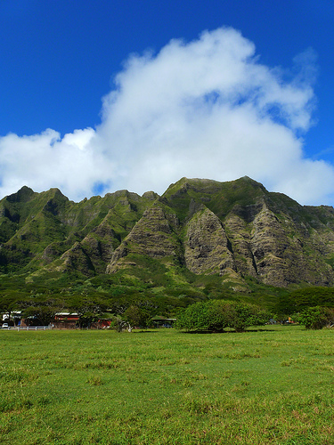
WaiKane in the region of Hawaii with its 778 inhabitants is a town in United States - some 4,821 mi or ( 7758 km ) West of Washington , the country's capital city .
Current time in WaiKane is now 06:06 PM (Friday) . The local timezone is named " Pacific/Honolulu " with a UTC offset of -10 hours. Depending on the availability of means of transportation, these more prominent locations might be interesting for you: Kane'ohe, Kokokahi, Lihue, Mahinui, and Mala'e. Since you are here already, make sure to check out Kane'ohe . We encountered some video on the web . Scroll down to see the most favourite one or select the video collection in the navigation. Where to go and what to see in WaiKane ? We have collected some references on our attractions page.
Videos
Sandy Beach Hawaii Huge Surf
This was the biggest surf I've ever seen at Sandy Beach (Oahu) in November 2003. Watch tow-in surfer at the end! ..
CHINAMAN'S HAT Kualoa Park Beach OAHU #71 Beaches Ocean Waves sounds HD Hawaii China mans
71 of 110 - RELAX NOW. Subscribe to the #1 Best Virtual Vacation Beach Resort Trip - "WAVES: Virtual Vacations" Relaxing Nature Videos: 15+ Million Views, Top Rated, Award Winning DVDs & Blu-Rays w/ O ..
Kaneohe Sandbar - August 31, 2008
My first trip out to the Kaneohe Sandbar - August 31, 2008. ..
Fishing Trip To Chinaman's Hat
Took a couple of friends out to Chinaman's Hat and hooked up some papio and barracuda. ..
Videos provided by Youtube are under the copyright of their owners.
Interesting facts about this location
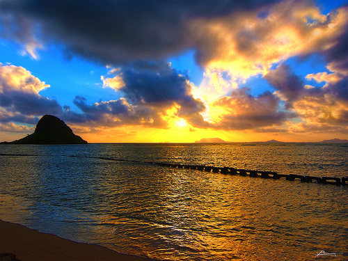
Mokoliʻi
Mokoliʻi is a 12.5-acre, 206-foot-tall basalt island ⁄3 miles offshore of Kualoa Point, Oahu, in Kāne'ohe Bay, Hawaii, at {{#invoke:Coordinates|coord}}{{#coordinates:21.5092|N|157.8297|W|scale:25000|||| |primary |name= }}. Geologically, it used to be connected to Oahu before erosion cut it off. It is also known as "Chinaman's Hat" for its likeness to the straw hats Chinese immigrants wore. Wedge-tailed Shearwaters are the only species of bird that nests here; previously there were a few.
Located at 21.51 -157.83 (Lat./Long.); Less than 3 km away
Kualoa Ranch
Kualoa Ranch is the landowner of Kaʻaʻawa Valley, also commonly known as Kualoa Valley, on the windward coast of the island of Oʻahu in Hawaiʻi. This place was sacred to ancient Oahuans from the 13th to the 18th century, as it was where Laʻa-mai-kahiki settled after visiting Kauaʻi and before returning to Tahiti. It was also the site of the sacred drums of Kapahuula and Kaahu-ulapunawai as well as the sacred Hill of Kauakahi-a-Kahoʻowaha, the key to the sovereignty of the Kingdom of Oahu.
Located at 21.52 -157.84 (Lat./Long.); Less than 3 km away
Kualoa Airfield
Kualoa Airfield is a former wartime airfield on Oahu, Hawaii. Part of it is now the Kualoa Regional Park.
Located at 21.53 -157.84 (Lat./Long.); Less than 3 km away
Ahupua'a O Kahana State Park
Ahupuaʻa O Kahana State Park, formerly Kahana Valley State Park, is located on the windward side of Oʻahu between Kaʻaʻawa and Punaluʻu. The park is located mauka (up hill) from Kahana Bay. It is Hawaii's only public ahupuaʻa, and it stretches from the sea to the tip of Puʻu Pauao at 2670 feet. It has a tropical climate, and it is one of the wettest areas in Oʻahu, averaging nearly 300 inches per year in parts of the valley. The main purpose of the park is to embrace and teach Hawaiian culture.
Located at 21.53 -157.87 (Lat./Long.); Less than 4 km away
Kahaluu, Hawaii
Kahaluʻu is a residential community and census-designated place (CDP) in the City and County of Honolulu, Hawaii, United States, in the District of Koolaupoko on the island of Oahu. In Hawaiian ka haluʻu means "diving place". As of the 2010 Census, the CDP had a total population of 4,738. At Kahaluʻu, visitors to the windward side travelling via the Pali Highway, H-3, or Likelike Highway first encounter the ocean close beside the highway (Kamehameha Highway or Route 83).
Located at 21.46 -157.84 (Lat./Long.); Less than 5 km away
Pictures

Related Locations
Information of geographic nature is based on public data provided by geonames.org, CIA world facts book, Unesco, DBpedia and wikipedia. Weather is based on NOAA GFS.